Historical rates of soil erosion in the Midwestern U.S.
Files
Download Data
Publication Date
2021
Keywords
soil erosion, geomorphology, Midwestern US, agriculture, native prairies
Disciplines
Environmental Monitoring | Geomorphology | Natural Resources and Conservation
Description
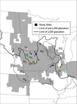
In the Midwestern U.S., erosion has caused native prairie remnants to become perched above surrounding farmland, providing an opportunity to measure historical soil loss. We conducted high-resolution topographic surveys across erosional escarpments at the boundary between 20 prairies and adjacent fields. Data were collected in 2016,2017, and 2019 in South Dakota, Nebraska, Minnesota, Iowa, and Illinois. Coordinates, elevation data, and transect number are given for each of the 20 locations. Coordinates are provided in UTM Zones 14, 15, or 16.
We used results from the topographic surveys and data from Lidar-derived elevation data to regionally scale estimates of soil loss and historically averaged erosion rates. For each county within the region, we calculated the historically averaged erosion rate and the modern erosion rate estimated by the USDA National Resources Inventory. The data for these analyses are provided as shapefiles.
DOI
https://doi.org/10.7275/76w5-1z60
Grant/Award Number and Agency
National Science Foundation # 1653191
Geological Society of America Graduate Student Research Grant
Recommended Citation
Thaler, Evan; Kwang, Jeffrey S.; and Larsen, Isaac J., "Historical rates of soil erosion in the Midwestern U.S." (2021). Data and Datasets. 138.
https://doi.org/10.7275/76w5-1z60
https://scholarworks.umass.edu/data/138