Files
Download Data (1226.4 MB)
Download Topographic wetness and Flow volume settings variables (266 KB)
Publication Date
2018
Disciplines
Environmental Sciences | Sustainability
Description
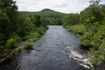
Topographic wetness and flow volume are two of several ecological settings variables that collectively characterize the biophysical setting of each 30 m cell at a given point in time (McGarigal et al 2017). These variables are two ways of assessing the flow of water; they share an underlying algorithm. Topographic wetness gives an estimate of the amount of moisture at any point in the landscape based on topography, which has a major effect on species habitat, soils, and the nutrient cycle. It ranges, in arbitrary units, from low values at hilltops and steep upper slopes to high values in low, flat areas with high flow accumulation. All lotic and lentic waterbodies share the same maximum value. Flow volume ranges in arbitrary units from 0 in uplands to a maximum in large rivers. It estimates the amount of water flowing into and through aquatic and wetland systems, which, along with gradient, largely determines species habitat and sediment transport. Flow volume is often coarsely estimated by stream order.
DOI
https://doi.org/10.7275/R5BZ648T
Recommended Citation
McGarigal, Kevin; Compton, Brad; Plunkett, Ethan; DeLuca, Bill; and Grand, Joanna, "Designing Sustainable Landscapes: Topographic wetness and Flow volume settings variables" (2018). Data and Datasets. 23.
https://doi.org/10.7275/R5BZ648T
https://scholarworks.umass.edu/data/23