Files
Download Data (7.2 MB)
Download Tidal Restrictions metric (458 KB)
Publication Date
2017
Disciplines
Environmental Sciences | Sustainability
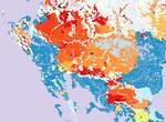
Description
Tidal restrictions include undersized culverts and bridges, tide gates, dikes, and other structures that interfere with normal tidal flushing in estuarine systems. Effects can range from mild changes in species composition and cycling of sediment and nutrients to wholesale conversion of ecological systems, such as conversion of Spartina-dominated salt marshes to Phragmites australis, or, in extreme cases, to freshwater wetlands (Roman et al. 1984, Ritter et al. 2008). The tidal restrictions metric is an element of the ecological integrity analysis of the Designing Sustainable Landscapes (DSL) project (see technical document on integrity, McGarigal et al 2017). Consisting of a composite of 21 stressor and resiliency metrics, the index of ecological integrity (IEI) assesses the relative intactness and resiliency to environmental change of ecological systems throughout the northeast. As a stressor metric, tidal restrictions uses an estimate of the historic loss of mapped salt marshes in areas where they should occur given elevation and tidal regime to indicate the location and magnitude of potential tidal restrictions. The metric estimates the effect of potential tidal restrictions on upstream wetland systems, including intertidal systems such as salt marshes, as well as freshwater systems and low-lying nonforested uplands that may have once been intertidal. Metric values range from 0 (no effect from downstream tidal restrictions) to 1 (severe effect). The metric is based on an estimate of the salt marsh loss ratio above each potential tidal restriction (road-stream and railroad-stream crossings). Note that tide gates not associated with roads are excluded as potential tidal restrictions, as they are not comprehensively mapped throughout the region. The salt marsh loss ratio is the proportion of a basin above a crossing that is modeled as potential salt marsh (from tide range and elevation) but not mapped as existing salt marsh in the National Wetlands Inventory (NWI) maps. Funding for this project was provided by the North Atlantic Landscape Conservation Cooperative and Department of the Interior Project #24, Decision Support for Hurricane Sandy Restoration and Future Conservation to Increase Resiliency of Tidal Wetland Habitats and Species in the Face of Storms and Sea Level Rise.
DOI
https://doi.org/10.7275/R5Q81B9C
Recommended Citation
McGarigal, Kevin; Compton, Brad; Plunkett, Ethan; DeLuca, Bill; and Grand, Joanna, "Designing Sustainable Landscapes: Tidal Restrictions metric" (2017). Data and Datasets. 28.
https://doi.org/10.7275/R5Q81B9C
https://scholarworks.umass.edu/data/28