Files
Download Data (221.9 MB)
Download DSLland and Subsysland (721 KB)
Publication Date
2017
Disciplines
Environmental Sciences | Sustainability
Description
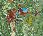
DSLland is the land cover map used as an organizational framework in the Designing Sustainable Landscapes (DSL) project (McGarigal et al 2017). It is derived primarily from The Nature Conservancy's Northeast Habitat Classification
map (Ferree and Anderson 2013; Anderson et al. 2013; Olivero and Anderson 2013; Olivero-Sheldon et al 2014). To meet the needs of the DSL project, we substantially modified the TNC map. The TNC map is a hierarchical classification. For our purposes, we adopted the 'habitat' level of the hierarchy, which we refer to as "ecosystems", as our finest scale, as it is the most appropriate classification for our ecological assessment. The attribute table also includes the ‘formation’ level for users that prefer a coarse classification.
DOI
https://doi.org/10.7275/R5P8494J
Recommended Citation
McGarigal, Kevin; Compton, Brad; Plunkett, Ethan; DeLuca, Bill; and Grand, Joanna, "Designing Sustainable Landscapes: DSLland and Subsysland" (2017). Data and Datasets. 36.
https://doi.org/10.7275/R5P8494J
https://scholarworks.umass.edu/data/36