Files
Download Data (14.6 MB)
Download HUC6 Watersheds documentation (PDF) (62 KB)
Publication Date
2018
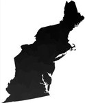
Description
This layer defines the subregions used for building cores in DSL landscape design (see technical document on landscape design, McGarigal et al 2017). It is based on the USGS Hydrologic Unit Codes (HUC) as extended in the USDA Watershed Boundary Dataset at the 6th level of the hierarchy (thus HUC6). In their original form these represent watersheds, sections of watersheds, and, especially in coastal areas, collections of watersheds of approximately equal size. They were chosen as the basic unit of our analysis because they were the size that stakeholders desired for subregions; are defined largely by natural boundaries, and are reasonably compact. We clipped the HUC6 boundaries to the Northeast Region and then manually edited the boundaries to make the HUCs and HUC fragments that remained within the Northeast Region more uniform in size and eliminate most disjunct HUC6s.
DOI
https://doi.org/10.7275/R5DR2SP3
Recommended Citation
McGarigal, Kevin; Plunkett, Ethan; Compton, Brad; DeLuca, Bill; and Grand, Joanna, "Designing Sustainable Landscapes: HUC6 Watersheds" (2018). Data and Datasets. 38.
https://doi.org/10.7275/R5DR2SP3
https://scholarworks.umass.edu/data/38