Files
Download Data (49.0 MB)
Download Northeast Aquatic Core Areas documentation (PDF) (144 KB)
Publication Date
2018
Description
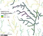
Northeast aquatic cores is one of the principal Designing Sustainable Landscapes (DSL) landscape conservation design (LCD) products for aquatic ecosystems and species, and it is best understood in the context of the full LCD process described in detail in the technical document on landscape design (McGarigal et al 2017). This particular set of products was developed for the entire Northeast region as part of the Nature's Network project (www.naturesnetwork.org) — a collaborative partnership under the auspices of the North Atlantic Landscape Conservation Cooperative (NALCC). Northeast aquatic cores represent a combination of lotic core areas (rivers and streams) and lentic core areas (lakes and ponds) selected at the Northeast regional scale to complement the lotic and lentic cores selected at the HUC6 scale (see aquatic cores document, McGarigal et al 2017) (Fig. 1).The HUC6 aquatic cores represent the primary LCD product for aquatic ecosystems; they were built to capture the best of each aquatic ecosystem in each HUC6 watershed in order to ensure a well-distributed network of aquatic cores across the region. However, the HUC6 scaling of the ecological integrity index (see IEI document, McGarigal et al 2017) from which the HUC6 cores were derived (see below) trades off some of the best areas of each aquatic ecosystem in the region for lower-valued areas in each HUC6 to achieve a more even distribution across the region for same total conserved area. The Northeast scaling of IEI forces the best areas of each ecosystem in the region to be included in the cores regardless of the final distribution.
DOI
https://doi.org/10.7275/5HM1-2548
Recommended Citation
McGarigal, Kevin; Compton, Brad; Plunkett, Ethan; DeLuca, Bill; and Grand, Joanna, "Designing Sustainable Landscapes: Northeast Aquatic Core Areas" (2018). Data and Datasets. 54.
https://doi.org/10.7275/5HM1-2548
https://scholarworks.umass.edu/data/54