Effective April 1, 2024 the UMass Amherst Libraries will be pausing submissions to ScholarWorks as we transition to a new software platform. If you'd like to submit an item during this pause, please use this submission form to OneDrive.
ScholarWorks offers long-term storage and public access to the data and datasets produced by labs and researchers at UMass Amherst. You can submit your own data to ScholarWorks, or email the Data Working Group to schedule an appointment, ask questions, or learn more about how to deposit your data with us!
-

Shifting hotspots: Climate change projected to drive contractions and expansions of invasive plant abundance ranges
Annette Evans, Evelyn M. Beaury, Peder S. Engelstad, Nathan B. Teich, and Bethany A. Bradley
This file contains maps of current and future abundance suitable habitat for 144 invasive plant species in the United States. Each tiff file represents the current or future range prediction maps of habitat suitable for supporting abundant populations (greater than or equal to 5% cover) of 144 invasive plant taxa, projected across the lower 48 States of the United States. Each tiff file is named with the USDA species code (SpCode) (see '1Species_information_Nov15.xlsx' file for full species names), with species codes followed by .2c indicating maps related to future climatic conditions under a +2oC warming scenario. Areas predicted to be climatically suitable for supporting abundant populations is based on model agreement and range from 0 (no models identify that area as suitable) to 15 (all model outputs identify the area as suitable). Values of 300 represent areas that are masked due to climate dissimilarity. See main publication for model fitting details.
-

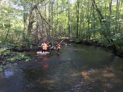
Data for "Distinct hydrologic pathways regulate perennial surface water dynamics in an arid basin"
Sarah McKnight, David F. Boutt, Lee Ann Munk, and Brendan Moran
In water-stressed arid basins, questions continue to mount over the compounding impacts of anthropogenic groundwater extraction and climate-driven perturbations on groundwater-surface water interactions and the resulting resilience of ecosystem-critical surface waters. Coupling groundwater and surface water level observations with surface water extents from Sentinel-2 data provides an unprecedented opportunity to evaluate surface water connectivity with local aquifers following intense, sporadic precipitation events in arid basins. Surface water area, surface water level, and groundwater level data were analyzed for trends following precipitation, including peak lag time, post-peak decline rates, and changes in hydraulic gradients. Results indicate variable connectivity following precipitation events between surface water change and groundwater level fluctuations in the upgradient freshwater aquifer with a Pearson correlation of 0.5-0.9, whereas the downgradient brine-to-brackish area of the aquifer indicated virtually no connectivity with the upgradient freshwater aquifer, having a correlation of $$ 0.9), though the log base value of that relationship spatially differs (0.01-0.03). Lumped parameter modeling of surface water inundation also constrains the possible hydrologic dynamics of the post-precipitation response of surface waters. While modeled influx to surface water seems primarily controlled by watershed hydraulics rather than direct hydraulic connectivity of the aquifers, the relationship between surface water and adjacent groundwater levels coupled with surface water area indicate that local aquifers are primarily connected to the surface water bodies through discharge via subsurface infiltration. Modeling results imply that the existence of brine-adjacent surface waters in arid basins are extremely reliant on upgradient discharge from freshwater aquifers despite limited implications for surface water being directly connected hydraulically with local aquifers, and yet that preferential pathways coupled with upgradient spring-fed runoff are a critical physical aspect of recharge to surface waters in arid basins. Our results further support that marginal surface water systems can themselves serve as a critical recharge mechanism to local aquifers.
-

Model data for 'The Paris Agreement and climate justice: inequitable impacts of sea level rise associated with temperature targets'
Shaina Sadai, Natalya Gomez, and Robert DeConto
This is the data repository associated with the manuscript "The Paris Agreement and climate justice: inequitable impacts of sea level rise associated with temperature targets". The data contained here is related to the sea level rise fingerprints generated for the study. These include the projected sea level rise fingerprint data at years 2100, 2200, and 2300 under emissions scenarios RCP4.5 and RCP8.5. For RCP4.5 data are from ice sheet simulations which include marine ice sheet instability. For RCP8.5 data is presented for two scenarios- one which includes only marine ice sheet instability and one that includes both marine ice sheet instability as well as marine ice cliff instability. Details about the content of the data repository can be found in the readme.txt file located in the repository.
-

The Intersection of Bee and Flower Sexes: Pollen Presence Shapes Sex-Specific Bee Foraging Associations in Sunflower
Justin C. Roch, Rosemary Malfi, Jennifer I. Van Wyk, Deicy Carolina Muñoz Agudelo, Joan Milam, and Lynn S. Adler
We evaluated whether female or male bees were more abundant on sunflowers, whether female bees were more abundant on pollen-fertile or pollen-sterile sunflower cultivars, and whether the bee community differed between pollen-fertile and pollen-sterile sunflower cultivars. We further evaluated whether bee communities were shaped by local floral resources and landscape composition. We sampled bees visiting sunflowers (Helianthus spp.) from 14 farms in the Connecticut River Valley of western Massachusetts between 25 July to 27 September 2019, typically making two sampling visits to a farm. We also measured floral resource diversity and abundance at the farms, and categorized the landscape types at 500 m, 1000 m, 1500 m, and 2500 m radii around the farms using GIS data. All sampled bees were identified to species or species complex. An associated manuscript with this title and these authors is being submitted for publication.
-

A cost-effective method to passively sample communities at the forest canopy-aerosphere interface
Michael Cunningham-Minnick, H. Patrick Roberts, Brian Kane Ph.D., Joan Milam, and David I. King Ph.D.
HOBO logger data of hourly measurements at canopy-aerosphere interface from June to August above temperate forest on campus of University of Massachusetts. Weather station data (precipitation and wind speeds) from nearby weather station extracted from Mesowest.com and needed for manuscript figures. Code (R language) to recreate foundation of figures in manuscript.
-

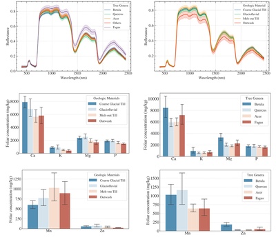
New England Foliar Spectral Reflectance and Nutrient Concentrations Data
Wenxiu Teng, Qian Yu, Ivan Mischenko, Alexandrea Rice, and Justin Richardson
-

Sleeper Species Database O'Uhuru et. al. 2022
Ayodelé O'Uhuru, Bethany A. Bradley, and Toni Lyn Morelli
Thousands of non-native plant species have been introduced and naturalized outside of their native ranges. A small portion of these naturalized species go on to become invasive, spreading away from sites where they initially naturalized and causing negative ecological impacts. In some cases, abiotic limitations, such as cold temperatures, prevent naturalized species from becoming invasive within all or a portion of their non-native range. However, rising temperatures due to climate change could lead to rapid population growth of some naturalized populations, triggering new invasions of these ‘sleeper populations’. Here, we present a database of impact assessments for 179 species naturalized in one or more northeastern state (CT, MA, ME, NH, NY, RI, VT). This database can be used to prioritize invasive species management to prevent the awakening of high-impact sleeper populations.
-

Sunflower plantings reduce a common gut pathogen and increase queen production in bumble bee colonies
Rosemary L. Malfi, Quinn S. McFrederick, Giselle Lozano, Rebecca E. Irwin, and Lynn S. Adler
We evaluated whether plantings of sunflower (Helianthus annuus), whose pollen reduces infection by some pathogens when fed to bees in captivity, lowered pathogen levels and increased reproduction in free-foraging bumble bee colonies (Bombus impatiens). We placed pairs of commercial colonies of B. impatiens at 20 mixed vegetable farms in western Massachusetts between Jul-23 and Oct-6 2019. Flowering resources typically visited by bumble bees were quantified at each farm twice to characterize abundance and diversity. We also visited each farm 3-4 times and at each visit, we (a) recorded colony weights to track growth, (b) collected ~10 corbicular loads from returning foragers (per site) to assess usage of sunflower and other Asteraceae, and (c) collected 10 returning foraging workers from each colony entrance for later pathogen analysis. Visual assessment of pathogen samples and pollen composition occurred at UMass Amherst during the 2019-20 academic year. Molecular assessment of pathogen samples occurred at UC Riverside. An associated manuscript with this title and these authors is being submitted for publication.
-

Assessment Data for "Envisioning the Future of a Mature IR"
Erin Jerome, Thea Atwood, Melanie Radik, and Rebecca M. Seifried
This dataset contains two spreadsheets: 1) an in-depth functionality assessment of Digital Commons based on the University of Pennsylvania's "Platform Functionality Review" (https://penntrl.wordpress.com/2019/01/23/scrip-appendices/); 2) a running list of required functionality for an institutional repository platform.
The spreadsheets accompany a forthcoming book chapter, "Envisioning the Future of a Mature IR: A Midlife Assessment of ScholarWorks@UMassAmherst".
-

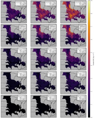
Forecasts of landscape evolution and soil organic carbon redistribution in the Midwestern United States
Jeffrey S. Kwang, Evan Thaler, and Isaac Larsen
In the Midwestern US, agricultural practices, i.e. tillage, causes soil erosion that changes how soil organic carbon (SOC) is naturally distributed across the landscape. We use a landscape evolution model (LEM) to predict how landscapes and SOC change from 2020 to 2520 across 410 counties located in Illinois, Indiana, Iowa, Kansas, Minnesota, Missouri, Nebraska, North Dakota, South Dakota, and Wisconsin. Initial distributions of SOC were estimated with the gridded Soil Survey Geographic (gSSURGO) dataset, maintained by the US Department of Agriculture, Natural Resources Conservation Service. The initial topography was built from various state LiDAR-derived (Light Detection and Ranging) digital elevation models.
For each county, the model outputs .tif files (every 80 years) that show the spatial distribution of elevation and SOC. In addition, .csv files are generated that record county-averaged values of soil erosion, soil deposition, SOC erosion, SOC deposition, and other variables at a higher temporal resolution (every 0.25 years).
-

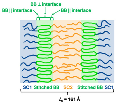
Source Data for "Medial packing and elastic asymmetry stabilize the double-gyroid in block copolymers"
Anugu Abhiram Reddy, Michael S. Dimittiyev, and Grason Gregory
Source code and data for "Medial packing and elastic asymmetry stabilize the double-gyroid in block copolymers."
Readme included in zip file.
-

Data for "Breaking down barriers to consistent, climate-smart regulation of invasive plants - a case study of northeast states"
Bethany A. Bradley, Evelyn M. Beaury, Emily J. Fusco, Lara Munro, Carrie Brown-Lima, Benjamin Kesler, Nancy Olmstead, and Jocelyn Parker
We evaluated regulatory weed risk assessment protocols for six northeast states (Connecticut, Maine, Massachusetts, New Hampshire, New York, and Vermont) to identify potential barriers to 1) consistent regulated plant lists across state borders and 2) proactive regulation of species that are not yet present in the state (e.g., range-shifting invasive plant species). We present lists of evaluated, regulated, and range-shifting invasive species that northeast states could assess to achieve consistent and proactive regulation.
-

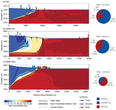
Data for "Relic Groundwater and Mega Drought Confound Interpretations of Water Sustainability and Lithium Extraction in Arid Lands"
Brendan J. Moran, David F. Boutt, Sarah V. McKnight, Jordan Jenckes, Lee Ann Munk, Daniel Corkran, and Alexander Kirshen
This repository contains raw data from this publication including hydrogeochemistry, model calculations, groundwater levels, and remotely sensed data compiled and extracted using Google Earth Engine.
-

North River and South River Estuary Tidal Marsh and Channel Sediment and Water Level Data
Hannah Baranes, Brian Yellen, Jonathan Woodruff, W Rockwell Geyer, Justin Richardson, and Frances Griswold
The data within this repository are observations from the North-South Rivers estuary and tidal marsh in the Massachusetts (USA) towns of Marshfield, Scituate, and Norwell. Types of data include 1) sediment core data, including x-ray fluorescence data, organic content, and foraminifera counts; 2) tidal channel observations of water level and turbidity; and 3) marsh platform observations of water level and turbidity.
-

Figures accompanying the manuscript "Mapping the Leigh Fermors’ Journey through the Deep Mani in 1951"
Rebecca M. Seifried and Chelsea A.M. Gardner
Figures accompanying a manuscript co-authored by Rebecca M. Seifried, Chelsea A.M. Gardner, and Maria Tatum called "Mapping the Leigh Fermors’ Journey through the Deep Mani in 1951." Creators/authors for each figure are included in the figure list.
-

GIS data for mapping the Leigh Fermors’ journey through the southern Mani Peninsula, Greece, in 1951
Rebecca M. Seifried and Chelsea A.M. Gardner
GIS data created by mapping Patrick (Paddy) and Joan Leigh Fermor's journey through the Mani peninsula in 1951. The zip file contains 6 layers (in GeoJSON format) that can be used to display least-cost models of portions of their route, the hikes we carried out to recreate them, and our final interpretation of their route from start to finish.
-

Source Data for "End exclusion zones in strongly stretched, molten polymer brushes of arbitrary shape"
Michael S. Dimitriyev and Gregory M. Grason
Supplementary code for solving the constraint equations that describe curved polymer brushes. Also contains software for analyzing the resulting solutions.
-

Invasion and Global Change Meta-analysis Data
Bianca E. Lopez, Jenica M. Allen, Jeffrey S. Dukes, Jonathan Lenoir, Montserrat Vilà, Dana M. Blumenthal, Evelyn M. Beaury, Emily J. Fusco, Toni Lyn Morelli, Cascade J. B. Sorte, and Bethany A. Bradley
We conducted a global meta-analysis to investigate invasions, abiotic global environmental changes, and their combined effects on native species, communities, and ecosystems.We searched the Web of Science Core Collection for articles and reviews that were available in English through September 30, 2020. Search terms were chosen to identify papers reporting impacts of invasions with one of six abiotic global environmental changes (GECs: warming, nitrogen deposition, O2 depletion, drought, CO2 addition, and altered pH). We assessed the titles and abstracts of the 5,662 returned papers and retained those that reported the ecological effects of: (a) one or more invasive species; (b) one or more GECs; (c) both invasive species and a GEC together; and (d) also reported data for a control treatment (no invasion and at current or ambient environmental conditions). From each study, we recorded data on means and variances of each measured response in the three treatments and control; the response measures (categorized into "response classes"); the introduced invasive species and hypothesized mechanism by which the invasion impacted the ecosystem; the type of GEC factor(s) manipulated; the ecosystem setting where the experiment took place (marine, terrestrial, or freshwater); and the type of experiment (laboratory/greenhouse, field, or mesocosm).
-

Winter malt barley growth, yield, and quality following leguminous cover crops in the Northeast United States
Arthur Siller, Heather Darby, Alexandra Smychkovich, and Masoud Hashemi
There is growing interest in malt barley (Hordeum vulgare L.) production in the Northeast United States. This crop must meet high quality standards for malting but can command a high price if these quality thresholds are met. A two-year field experiment was conducted from 2015–2017 to evaluate the impact of two leguminous cover crops, sunn hemp (Crotalaria juncea L.) and crimson clover (Trifolium incarnatum L.), on subsequent winter malt barley production. Four cover crop treatments –sunn hemp (SH), crimson clover (CC), sunn hemp and crimson clover mixture (SH+CC), and no cover crop (NC) – were grown before planting barley at three seeding rates (300, 350, and 400 seeds m–2). SH and SH+CC produced significantly more biomass and residual nitrogen than the CC and NC treatments. Higher barley seeding rates led to higher seedling density and winter survival. However, the subsequent spring and summer barley growth metrics, yield, and malt quality were not different in any of the treatments. There is much left to investigate in determining the best malt barley production practices in the Northeast United States, but these results show that winter malt barley can be integrated into crop rotations with leguminous plants without negative impacts on barley growth, yield, and grain quality.
-

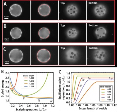
Load-Bearing Entanglements in Polymer Glasses
Cynthia Bukowski, Tianren Zhang, Robert A. Riggleman, and Alfred J. Crosby
Data for "Load-bearing entanglements in polymer glasses" Cynthia Bukowski, Tianren Zhang, Robert A. Riggleman, Alfred J. Crosby. 2021.
Experimental and simulation data describing the mechanical response of glassy polymer blends in a thin film state. Blends are made of long and short chain polymers. The load-bearing entanglement network is quantified.
-

Freshwater Tidal Wetland Sediment Flux in the Hudson River, NY
Kelly McKeon and Jonathan Woodruff
This study primarily used a 16-year tidal flux dataset generated by the Hudson River National Estuarine Research Reserve (HRNERR) to generate highly detailed sediment budgets for two freshwater tidal wetlands in the Hudson River. Throughout this dataset, Tivoli North Bay is a marsh and files associated with it will be labeled TVN. Tivoli South Bay is a mudflat and files associated with this bay will be labelled TVS. The HRNERR dataset is publicly available through their centralized data management office at cdmo.baruch.sc.edu. To supplement the publicly available water level, turbidity, and suspended sediment concentration (SSC) data, we deployed additional current meters and water level loggers at openings to each bay, placed sediment traps on the marsh platform, and collected sediment cores in the mudflat. Tiltmeter, HOBO water level-logger, and ADCP current measurements are included here, as well as loss-on-ignition data from water filters and sediment traps, and Cs-137 values from sediment cores. We use the synthesis of these data with the HRNERR data to estimate net sediment import and export from both the marsh and the mudflat between 2004 and 2019.
-

Historical rates of soil erosion in the Midwestern U.S.
Evan Thaler, Jeffrey S. Kwang, and Isaac J. Larsen
In the Midwestern U.S., erosion has caused native prairie remnants to become perched above surrounding farmland, providing an opportunity to measure historical soil loss. We conducted high-resolution topographic surveys across erosional escarpments at the boundary between 20 prairies and adjacent fields. Data were collected in 2016,2017, and 2019 in South Dakota, Nebraska, Minnesota, Iowa, and Illinois. Coordinates, elevation data, and transect number are given for each of the 20 locations. Coordinates are provided in UTM Zones 14, 15, or 16.
We used results from the topographic surveys and data from Lidar-derived elevation data to regionally scale estimates of soil loss and historically averaged erosion rates. For each county within the region, we calculated the historically averaged erosion rate and the modern erosion rate estimated by the USDA National Resources Inventory. The data for these analyses are provided as shapefiles.
-

Plant regulatory lists in the U.S. are reactive and inconsistent - Appendix 1
Evelyn M. Beaury, Emily J. Fusco, Jenica M. Allen, and Bethany A. Bradley
This file includes supplemental information for Beaury, E.M.*, Fusco, E.J., Allen, J.M., Bradley, B.A. Plant regulatory lists in the U.S. are reactive and inconsistent. Journal of Applied Ecology. The file contains the sources for regulated plant lists, the lists themselves, and summarized findings of the study (whether taxa are listed proactively or as climate change proactive). Metadata are included in the file.
*corresponding author: Evelyn M. Beaury (ebeaury@umass.edu), 312B Holdsworth Hall, University of Massachusetts Amherst, Amherst, MA, 01002.
-

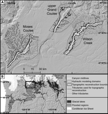
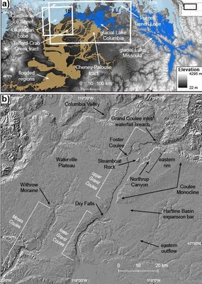
Source data for "Narrower Paleo-canyons Downsize Megafloods"
Scott R. David, Isaac Larsen, and Michael P. Lamb
The data provided in this repository is the source data for "Narrower Paleo-canyons Downsize Megafloods". The repository contains 3 main directories: 1) Hydro_Models (hydrodynamic modeling data), 2) Topo_Reconstruction (topographic reconstruction data), and 3) Analysis_Scripts (data analysis scripts). The Hydro_Models directory contains all inputs, outputs, and python scripts used for the ANUGA flood simulations. The Topo_Reconstruction directory contains all inputs, outputs, and Matlab scripts used in the artificial neural network analysis. The Analysis_Scripts folder contains Matlab scripts to analyze flood hydraulics and sediment routing, and to reproduce plots.
-

Source Data for "Block copolymers beneath the surface: measuring and molding complex morphology at the sub-domain scale"
Abhiram Reddy, Edwin Thomas, and Greg Grason