
-

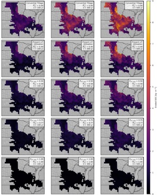
Forecasts of landscape evolution and soil organic carbon redistribution in the Midwestern United States
Jeffrey S. Kwang, Evan Thaler, and Isaac Larsen
In the Midwestern US, agricultural practices, i.e. tillage, causes soil erosion that changes how soil organic carbon (SOC) is naturally distributed across the landscape. We use a landscape evolution model (LEM) to predict how landscapes and SOC change from 2020 to 2520 across 410 counties located in Illinois, Indiana, Iowa, Kansas, Minnesota, Missouri, Nebraska, North Dakota, South Dakota, and Wisconsin. Initial distributions of SOC were estimated with the gridded Soil Survey Geographic (gSSURGO) dataset, maintained by the US Department of Agriculture, Natural Resources Conservation Service. The initial topography was built from various state LiDAR-derived (Light Detection and Ranging) digital elevation models.
For each county, the model outputs .tif files (every 80 years) that show the spatial distribution of elevation and SOC. In addition, .csv files are generated that record county-averaged values of soil erosion, soil deposition, SOC erosion, SOC deposition, and other variables at a higher temporal resolution (every 0.25 years).
-

Data for "Distinct hydrologic pathways regulate perennial surface water dynamics in an arid basin"
Sarah McKnight, David F. Boutt, Lee Ann Munk, and Brendan Moran
In water-stressed arid basins, questions continue to mount over the compounding impacts of anthropogenic groundwater extraction and climate-driven perturbations on groundwater-surface water interactions and the resulting resilience of ecosystem-critical surface waters. Coupling groundwater and surface water level observations with surface water extents from Sentinel-2 data provides an unprecedented opportunity to evaluate surface water connectivity with local aquifers following intense, sporadic precipitation events in arid basins. Surface water area, surface water level, and groundwater level data were analyzed for trends following precipitation, including peak lag time, post-peak decline rates, and changes in hydraulic gradients. Results indicate variable connectivity following precipitation events between surface water change and groundwater level fluctuations in the upgradient freshwater aquifer with a Pearson correlation of 0.5-0.9, whereas the downgradient brine-to-brackish area of the aquifer indicated virtually no connectivity with the upgradient freshwater aquifer, having a correlation of $$ 0.9), though the log base value of that relationship spatially differs (0.01-0.03). Lumped parameter modeling of surface water inundation also constrains the possible hydrologic dynamics of the post-precipitation response of surface waters. While modeled influx to surface water seems primarily controlled by watershed hydraulics rather than direct hydraulic connectivity of the aquifers, the relationship between surface water and adjacent groundwater levels coupled with surface water area indicate that local aquifers are primarily connected to the surface water bodies through discharge via subsurface infiltration. Modeling results imply that the existence of brine-adjacent surface waters in arid basins are extremely reliant on upgradient discharge from freshwater aquifers despite limited implications for surface water being directly connected hydraulically with local aquifers, and yet that preferential pathways coupled with upgradient spring-fed runoff are a critical physical aspect of recharge to surface waters in arid basins. Our results further support that marginal surface water systems can themselves serve as a critical recharge mechanism to local aquifers.
-

Model data for 'The Paris Agreement and climate justice: inequitable impacts of sea level rise associated with temperature targets'
Shaina Sadai, Natalya Gomez, and Robert DeConto
This is the data repository associated with the manuscript "The Paris Agreement and climate justice: inequitable impacts of sea level rise associated with temperature targets". The data contained here is related to the sea level rise fingerprints generated for the study. These include the projected sea level rise fingerprint data at years 2100, 2200, and 2300 under emissions scenarios RCP4.5 and RCP8.5. For RCP4.5 data are from ice sheet simulations which include marine ice sheet instability. For RCP8.5 data is presented for two scenarios- one which includes only marine ice sheet instability and one that includes both marine ice sheet instability as well as marine ice cliff instability. Details about the content of the data repository can be found in the readme.txt file located in the repository.
-

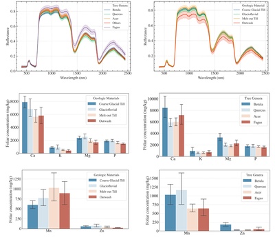
New England Foliar Spectral Reflectance and Nutrient Concentrations Data
Wenxiu Teng, Qian Yu, Ivan Mischenko, Alexandrea Rice, and Justin Richardson
-

North River and South River Estuary Tidal Marsh and Channel Sediment and Water Level Data
Hannah Baranes, Brian Yellen, Jonathan Woodruff, W Rockwell Geyer, Justin Richardson, and Frances Griswold
The data within this repository are observations from the North-South Rivers estuary and tidal marsh in the Massachusetts (USA) towns of Marshfield, Scituate, and Norwell. Types of data include 1) sediment core data, including x-ray fluorescence data, organic content, and foraminifera counts; 2) tidal channel observations of water level and turbidity; and 3) marsh platform observations of water level and turbidity.
-

Source data for "Narrower Paleo-canyons Downsize Megafloods"
Scott R. David, Isaac Larsen, and Michael P. Lamb
The data provided in this repository is the source data for "Narrower Paleo-canyons Downsize Megafloods". The repository contains 3 main directories: 1) Hydro_Models (hydrodynamic modeling data), 2) Topo_Reconstruction (topographic reconstruction data), and 3) Analysis_Scripts (data analysis scripts). The Hydro_Models directory contains all inputs, outputs, and python scripts used for the ANUGA flood simulations. The Topo_Reconstruction directory contains all inputs, outputs, and Matlab scripts used in the artificial neural network analysis. The Analysis_Scripts folder contains Matlab scripts to analyze flood hydraulics and sediment routing, and to reproduce plots.
-

The Paris Climate Agreement and future sea level rise from Antarctica
Robert M. DeConto, David Pollard, Richard B. Alley, Isabella Velicogna, Edward Gasson, Natalya Gomez, Shaina Sadai, Alan Condron, Daniel M. Gilford, Erica L. Ashe, Robert E. Kopp, Dawei Li, and Andrea Dutton
Three dimensional ice sheet model output for select model simulations in netCDF format.
Please click the blue download button to download 3deg.nc (18MB).
-

Model data for 'CO2 and Tectonic Controls on Antarctic Climate and Ice-Sheet Evolution in the Mid-Miocene'
Anna Ruth Halberstadt
This is the data repository associated with the manuscript "CO2 and Tectonic Controls on Antarctic Climate and Ice-Sheet Evolution in the Mid-Miocene" containing all model output files relevant to the project. We use an ensemble of asynchronously coupled climate - ice sheet - vegetation model simulations spanning a range of CO2 concentrations, Transantarctic Mountain uplift scenarios, and glacial/interglacial climatic conditions to identify climate and ice-sheet conditions consistent with Antarctic mid-Miocene terrestrial and marine geological records. Details about the content of the data repository can be found in the readme.txt file located in the repository.
-

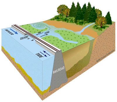
Freshwater Tidal Wetland Sediment Flux in the Hudson River, NY
Kelly McKeon and Jonathan Woodruff
This study primarily used a 16-year tidal flux dataset generated by the Hudson River National Estuarine Research Reserve (HRNERR) to generate highly detailed sediment budgets for two freshwater tidal wetlands in the Hudson River. Throughout this dataset, Tivoli North Bay is a marsh and files associated with it will be labeled TVN. Tivoli South Bay is a mudflat and files associated with this bay will be labelled TVS. The HRNERR dataset is publicly available through their centralized data management office at cdmo.baruch.sc.edu. To supplement the publicly available water level, turbidity, and suspended sediment concentration (SSC) data, we deployed additional current meters and water level loggers at openings to each bay, placed sediment traps on the marsh platform, and collected sediment cores in the mudflat. Tiltmeter, HOBO water level-logger, and ADCP current measurements are included here, as well as loss-on-ignition data from water filters and sediment traps, and Cs-137 values from sediment cores. We use the synthesis of these data with the HRNERR data to estimate net sediment import and export from both the marsh and the mudflat between 2004 and 2019.
-

Data for "Relic Groundwater and Mega Drought Confound Interpretations of Water Sustainability and Lithium Extraction in Arid Lands"
Brendan J. Moran, David F. Boutt, Sarah V. McKnight, Jordan Jenckes, Lee Ann Munk, Daniel Corkran, and Alexander Kirshen
This repository contains raw data from this publication including hydrogeochemistry, model calculations, groundwater levels, and remotely sensed data compiled and extracted using Google Earth Engine.
-

Historical rates of soil erosion in the Midwestern U.S.
Evan Thaler, Jeffrey S. Kwang, and Isaac J. Larsen
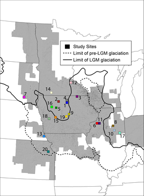
In the Midwestern U.S., erosion has caused native prairie remnants to become perched above surrounding farmland, providing an opportunity to measure historical soil loss. We conducted high-resolution topographic surveys across erosional escarpments at the boundary between 20 prairies and adjacent fields. Data were collected in 2016,2017, and 2019 in South Dakota, Nebraska, Minnesota, Iowa, and Illinois. Coordinates, elevation data, and transect number are given for each of the 20 locations. Coordinates are provided in UTM Zones 14, 15, or 16.
We used results from the topographic surveys and data from Lidar-derived elevation data to regionally scale estimates of soil loss and historically averaged erosion rates. For each county within the region, we calculated the historically averaged erosion rate and the modern erosion rate estimated by the USDA National Resources Inventory. The data for these analyses are provided as shapefiles.
-

Dam Impoundments Sediment Mass – Tributaries to the Hudson River
Brian Yellen and Jonathan Woodruff
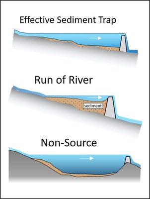
This repository contains data from sediment cores collected during 2017-2018 from 17 impoundments that are located on tributaries to the tidal portion of the Hudson River as part of a larger NERRs collaborative project entitled Dams and Sediment on the Hudson (DaSH). A companion dataset that contains sediment core data from Hudson tidal marshes is archived at UMass Scholarworks data repository. Sediment cores collected from impoundments behind dams were recovered via piston push coring, which tends to minimize compaction and be representative of true sediment thicknesses. The general workflow for cores included (1) splitting; (2) Itrax XRF scanning; (3) subsampling cores ~10 cm spacing; (4) drying and burning samples for percent water, organic, and mineral (Dean, 1974). Combusted samples were gently disaggregated with mortar and pestle and analyzed for grain size on a Coulter Laser Particle Size Analyzer. Basal sediments were identified by low organic content and a contrast in grainsize or sediment texture with overlying pond sediment. Sediment age was constrained by the construction date of the corresponding dam, when that information was available, and by 137Cs chronology when absent. The small sediment masses present in most of these dams relative to expected masses based on regional sediment yield is representative of the small aggregate trapping of sediment by legacy mill dams in the Northeast US, highlighted in the manuscript “Watershed sediment supply and potential impacts of dam removals for an estuary,” submitted to Estuaries and Coasts in March, 2020.
-

Hudson River Estuary Tidal Marsh Sediment Data
Brian Yellen and Jonathan Woodruff
This repository contains data from sediment cores collected at six tidal wetland complexes that are located within the Hudson River Estuary. The sites include Stockport Marsh, Esopus Delta, Tivoli North Bay, Tivoli South Bay, Vanderburgh Cove, and Iona Island Marsh. A variety of core collection tools and methods were used to collect uncompacted records, including gouge coring, Russian peat coring, and piston push coring, with the method determined by coring environment. The general workflow for cores included (1) splitting; (2) Itrax XRF scanning; (3) subsampling cores ~10 cm spacing; (4) drying and burning samples for percent water, organic, and mineral content. Gamma spectroscopy was used to identify down-core profiles of 137Cs and 210Pb in at least one representative core from each site. Relative abundance and onset of heavy metals zinc (Zn) and lead (Pb) as recorded in X-ray Flourecense (XRF) data were used as additional supportive age constraint in cores. Collectively, data from these cores provide evidence within the tidal freshwater Hudson River for rapid accretion within anthropogenic tidal freshwater wetlands relative to those that developed prior to the industrial era.
Printing is not supported at the primary Gallery Thumbnail page. Please first navigate to a specific Image before printing.