Effective April 1, 2024 the UMass Amherst Libraries will be pausing submissions to ScholarWorks as we transition to a new software platform. If you'd like to submit an item during this pause, please use this submission form to OneDrive.
ScholarWorks offers long-term storage and public access to the data and datasets produced by labs and researchers at UMass Amherst. You can submit your own data to ScholarWorks, or email the Data Working Group to schedule an appointment, ask questions, or learn more about how to deposit your data with us!-

Data for Dopant-induced Energetic Disorder in Conjugated Polymers: Determinant Roles of Polymer-Dopant Distance and Composite Electronic Structures
Michael Lu Diaz, Muhamed Duhandzic, Simon Harrity, Subhayan Samanta, Zlatan Aksamija, and Dhandapani Venkataraman
The data here is the raw data for Figures in the publication "Dopant-Induced Energetic Disorder in Conjugated Polymers: Determinant Roles of Polymer−Dopant Distance and Composite Electronic Structures" In the Journal of Physical Chemistry C. (https://doi.org/10.1021/acs.jpcc.3c07197)
-

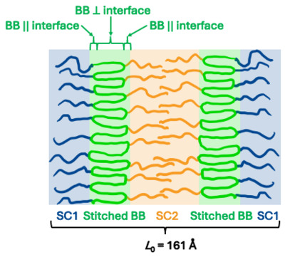
Source Data for Mingqiu Hu, Hong-Gyu Seong, Michael S. Dimitriyev, Weiguo Hu, Zhan Chen, Gregory M. Grason, Todd Emrick, and Thomas P. Russell, "Backbone chain stitching in bottlebrush statistical copolymers"
Mingqiu Hu, Hong-Gyu Seong, Michael S. Dimitriyev, Weiguo Hu, Zhan Chen, Grason M. Gregory, Todd S. Emrick, and Thomas P. Russell
-

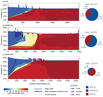
Data for "Density constrains environmental impacts of fluid abstraction in continental lithium brines"
Daniel B. Corkran, David F. Boutt, Lee Ann Munk, Brendan J. Moran, Sarah McKnight, Jordan Jenckes, and Alexander Kirshen
This dataset contains all data used in the study "Density constrains environmental impacts of fluid abstraction in continental lithium brines." Data include all SEAWAT groundwater-flow model input and output files, which contain all data associated with the parametric modeling study. It also contains NDVI and total annual precipitation datasets used in the study's remote sensing analysis.
-

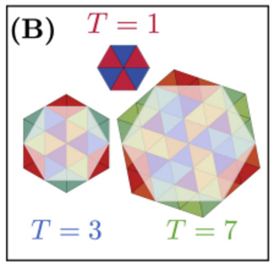
Limits of economy and fidelity for programmable assembly of size-controlled triply-periodic polyhedra
Carlos M. Duque, Douglas M. Hal, Botond Tyukodi, Michael F. Hagan, Christian D. Santangelo, and Gregory M. Grason
We propose and investigate an extension of the Caspar-Klug symmetry principles for viral capsid assembly to the programmable assembly of size-controlled triply-periodic polyhedra, discrete variants of the Primitive, Diamond, and Gyroid cubic minimal surfaces. Inspired by a recent class of programmable DNA origami colloids, we demonstrate that the economy of design in these crystalline assemblies -- in terms of the growth of the number of distinct particle species required with the increased size-scale (e.g. periodicity) -- is comparable to viral shells. We further test the role of geometric specificity in these assemblies via dynamical assembly simulations, which show that conditions for simultaneously efficient and high-fidelity assembly require an intermediate degree of flexibility of local angles and lengths in programmed assembly. Off-target misassembly occurs via incorporation of a variant of disclination defects, generalized to the case of hyperbolic crystals. The possibility of these topological defects is a direct consequence of the very same symmetry principles that underlie the economical design, exposing a basic tradeoff between design economy and fidelity of programmable, size controlled assembly.
-

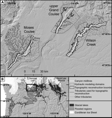
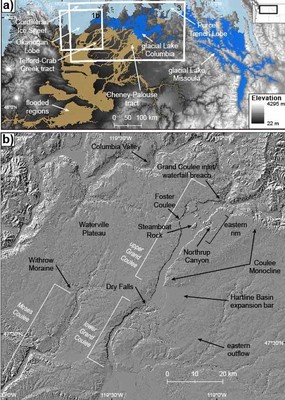
Data for "Rates of bedrock canyon incision by megafloods, Channeled Scabland, USA"
Karin E. Lehnigk, Isaac J. Larsen, Michael P. Lamb, and Scott R. David
This is the data repository associated with the manuscript 'Rates of bedrock canyon incision by megafloods, Channeled Scabland, USA,' containing all code, input files, and output files relevant to the project. Details about the content of the data repository can be found in the readme.txt file located in the repository.
-

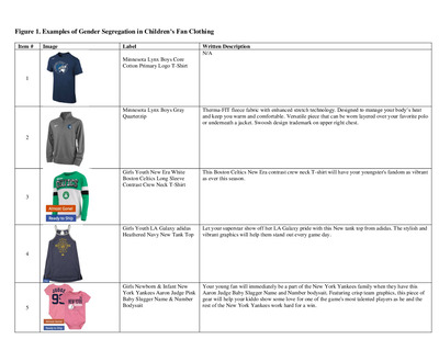
Supplementary Data Figures for Manuscript: Selling Gender Through Kids’ Sport Team Merchandise: A Multimodal Critical Discourse Analysis
Katie L. Sveinson and Charles D.T. Macaulay
Supplementary data figures for manuscript titled Selling Gender Through Kids’ Sport Team Merchandise: A Multimodal Critical Discourse Analysis published in the Journal of Sport Management.
Additional data figures created to provide more raw data and examples.
-

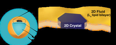
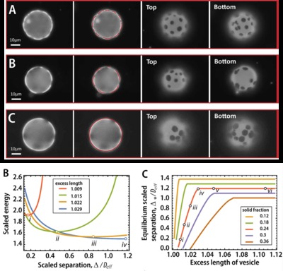
Source data for "Flowering of Developable 2D Crystal Shapes in Closed, Fluid Membranes"
Hao Wan, Geunwoong Jeon, Weiyue Xin, Gregory M. Grason, and Maria M. Santore
Source data for "Flowering of Developable 2D Crystal Shapes in Closed, Fluid Membranes".
-

Data for "Human activity drives establishment, but not invasion, of non-native plants on islands"
William Pfadenhauer and Bethany Bradley
-

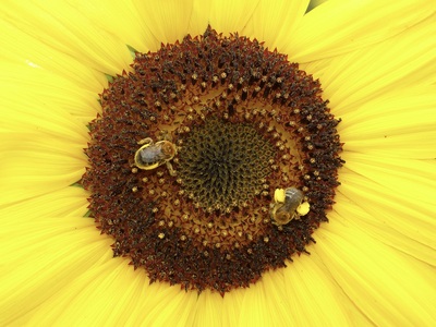
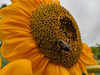
Data and R code for "Gut Transplants from Bees Fed an Antipathogenic Pollen Diet Do Not Confer Pathogen Resistance to Recipients"
Rachel T. Yost, Alison E. Fowler, and Lynn S. Adler
Pollinators are threatened by diverse stressors, including microbial pathogens such as Crithidia bombi. Consuming sunflower pollen dramatically reduces C. bombi infection in the bumble bee Bombus impatiens, but the mechanism behind this medicinal effect is unclear. We asked whether diet mediates resistance to C. bombi through changes in the gut microbiome. We hypothesized that sunflower pollen changes the gut microbiome, which in turn reduces Crithidia infection. To test this, we performed a gut transplant experiment. We fed donor bees either a sunflower pollen treatment or buckwheat pollen as a control treatment, and then inoculated recipient bees with homogenized guts from either sunflower-fed or buckwheat-fed donor bees. All recipient bees were then fed a wildflower pollen diet. Two days after the transplant, we infected recipients with C. bombi, and two days later, we provided another donor gut transplant. To quantify infection, we performed both fecal screens and dissections of the recipient bees. We found no significant differences in C. bombi infection intensity or presence between bees that received sunflower-fed microbiomes versus buckwheat-fed microbiomes. This suggests that sunflower pollen's effects on pathogen resistance are not mediated by gut microbiota.
-

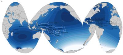
Data for "Hydrological Signatures in wetlands in the Li-rich salar basins of the Andes, South America"
Sarah McKnight, Jordan Jenckes, David Boutt, Brendan Moran, Lee Ann Munk, and Alexander Kirshen
Data relevant to regional study of surface water inundation dynamics, vegetative areas, temperature, and precipitation in the Andes of South America.
-

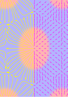
Supplementary Code for "Chain trajectories, domain shapes and terminal boundaries in block copolymers"
Benjamin R. Greenvall, Michael S. Dimitriyev, and Gregory M. Grason
Supplementary code used for the publication "Chain trajectories, domain shapes and terminal boundaries in block copolymers" by Benjamin R. Greenvall, Michael S. Dimitriyev, and Gregory M. Grason. Includes code for extracting and analyzing polar order and chain trajectories from self-consistent field calculations of block copolymers.
-

Sucrose Concentration and Fermentation Temperature Impact the Sensory Characteristics and Liking of Kombucha - Data
Gil Cohen, David A. Sela, and Alissa A. Nolden
In this data set we can see the pH, brix, and titratable acidity measurements in triplicate, as well as the sensory study data. The kombucha batches were combined prior to sensory testing and measured for their combined titratable acidity as well.
-

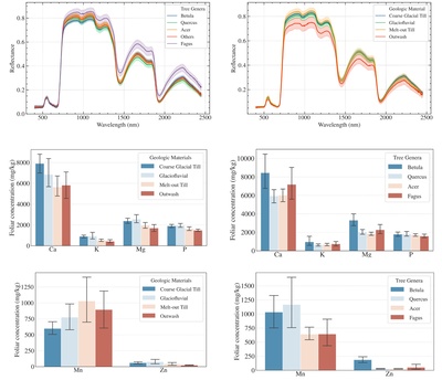
Thames River subwatershed soil, sediment, water data
Justin B. Richardson and Mark J. Butler
Trace element and nutrient data are for riparian soils, suspended sediments, eddy bottom sediments, and river water collected between 2019 and 2020 in the Thames River watershed of Connecticut, USA. Trace elements and nutrients were measured using EPA 3050B digestion method and analyzed by ICP-OES or ICP-MS.
-

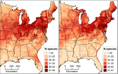
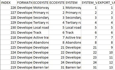
Taxonomic relationships of established plant species in the conterminous United States
Daniel Buonaiuto, Annette Evans, Mathew Fertakos, William Pfadenhauer, Justin Salva, and Bethany Bradley
Invasion status of non-native vascular plants established in the conterminous United States and their phylogenetic relationships to other invaders at multiple taxonomic resolutions.
-
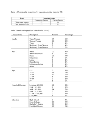
Justice - How Race, Class, and Gender Shape Experiences of Family Formation and Parenthood by Derek Siegel")
Trans Women and Reproductive (In)Justice - How Race, Class, and Gender Shape Experiences of Family Formation and Parenthood
Derek Siegel
The following support document includes demographic data from my dissertation research, disaggregated to preserve the anonymity of respondents. It also includes two separate interview schedules for semi-structured interviews I conducted with trans women who were either currently parents (the first guide) or who want to be parents in the future (the second guide). My dissertation examines how race, class, and gender shape trans women’s parenting journeys. Trans women, and particularly trans women of color, experience high levels of discrimination across the contexts of employment, healthcare, and the legal system, yet remain virtually absent from contemporary research on family and parenting inequalities. I have conducted 54 semi-structured interviews with current and prospective parents across North America, including 27 white trans women and 27 trans women of color. Using the intersectional concepts of transmisogyny and racialized transmisogyny, I argue that trans women face unique barriers to parenting and becoming a parent but also share challenges with other minoritized parents. My findings speak more broadly to theory regarding the increased policing and regulation of motherhood (i.e., reproductive governance), the perceived link between motherhood and womanhood (i.e., R.W. Connell’s concept of mis/recognition), and ongoing transformations in family structure (i.e., queer and trans kinship studies). Whereas existing research on trans women often reduces them to victims of violence, my research highlights trans women’s resilience, resistance, and their ability to build families and community networks despite institutional barriers.
-
 database: Documenting the spatiotemporal history of plant sales in the conterminous U.S. by Matthew Fertakos, Evelyn M. Beaury, Neil R. Ford, Nicole L. Kinlock, Denise W. Adams, and Bethany Bradley")
Historical plant sales (HPS) database: Documenting the spatiotemporal history of plant sales in the conterminous U.S.
Matthew Fertakos, Evelyn M. Beaury, Neil R. Ford, Nicole L. Kinlock, Denise W. Adams, and Bethany Bradley
The purpose of this database was to extract, standardize, and geocode the historical trade of vascular and non-vascular plant taxa sold in the horticultural industry of the conterminous United States. The HPS database aims to serve as a resource for analysis of contemporary patterns of introduced and invasive plants as well as for identifying opportunities to expand native plant sales in horticulture. Key data sources that make up this database include the Biodiversity Heritage Library's Seed and Nursery Catalog Collection, and the book Restoring American Gardens by D.W. Adams.
-

A comparison of three queen rearing techniques to improve sustainable small-scale beekeeping in the Northeast US
Hannah R. Whitehead, Ang Roell, Samuel A. Comfort, Bi Kline, and Lynn Adler
-

Appendix 1. Database of EICAT impact assessment summaries for 169 potential sleeper invasive plants in the Northeast United States
Ayodelé C. O'Uhuru, Bethany A. Bradley, Toni Lyn Morelli, and Justin Salva
Environmental Impacts Classification of Alien Taxa (EICAT) assessments for 169 introduced, established plants in the Northeast (states of CT, MA, ME, NH, NY, RI, VT) that could become invasive with climate change.
-

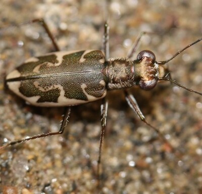
Rainbow Beach Sediment Grain Size Analysis, Northampton, Massachusetts
Brian Yellen
This dataset was prepared by Brian Yellen, a research assistant professor in the Department of Earth, Geographic, and Climate Sciences at the University of Massachusetts Amherst. Dr. Yellen worked in conjunction with Melissa Grader of the USFWS and colleagues to conduct the associated field sampling.
This report provides information related to the substrate grain size at surveyed locations on Rainbow Beach on the Connecticut River in Northampton, MA (42.322125, -72.584928). This location is a known breeding site of the endangered puritan tiger beetle (PTB), Ellipsoptera puritana.
-

Source Data for Xueyan Feng, Michael S. Dimitriyev & Edwin L. Thomas, "Soft, malleable double diamond twin"
Xueyan Feng, Michael S. Dimitriyev, and Edwin L. Thomas
Source data and code for Xueyan Feng, Michael S. Dimitriyev & Edwin L. Thomas, "Soft, malleable double diamond twin"
-

The influence of erosion and vegetation on soil production and chemical weathering rates in the Southern Alps, New Zealand
Isaac Larsen, Andre Eger, Peter C. Almond, Evan Thaler, J. Michael Rhodes, and Günther Prasicek
This data repository contains Supplementary Tables S1 – S13 which mirror files hosted by the publisher. The repository additionally contains a 0.5 m digital elevation model (DEM) derived from historical aerial photographs using structure-from-motion and multiple raster files of topographic derivatives of the DEM. The topographic derivatives include a raster of slope, mean local relief, and 56 rasters of topographic curvature, calculated using different combinations of smoothing window sizes (0, 0.5, 1, 1.5, 2, 2.5, 3, 3.5, 4, 4.5, 5, 7.5, 10, and 12.5 m) and the number of grid cells used in the surfaces for which curvature was constructed (3, 5, 7, and 9 cells).
-

Abundant, distinct, and seasonally dynamic bee community in the canopy-aerosphere interface above a temperate forest: Associated Data
Michael J. Cunningham-Minnick, Joan Milam, Brian Kane, H. Patrick Roberts, and David I. King
This dataset describes bees (Apoidea) sampled with blue vane traps at different heights within and above a temperate forest on the campus of University of Massachusetts Amherst from April through August of 2021, as well as the R-code used for data analyses. Specifically, it includes 2 files: 1) all data on individual specimens, including species identifications, occurrence dates and coordinates, and more information on encounter location and study design, and 2) All code used to generate figures and tables from the data that are included within the published manuscript.
-

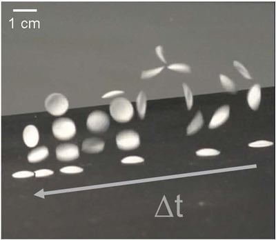
Source Data for Self-Spinning Filaments for Autonomously Linked Microfibers
Dylan M. Barber, Todd S. Emrick, Gregory Grason, and Alfred Crosby
Filamentous bundles are ubiquitous in Nature, achieving highly adaptive functions and structural integrity from assembly of diverse mesoscale supramolecular elements. Engineering routes to synthetic, topologically integrated analogs demands precisely coordinated control of multiple filaments’ shapes and positions, a major challenge when performed without complex machinery or labor-intensive processing. Here, we demonstrate a photocreasing design that encodes local curvature and twist into mesoscale polymer filaments, enabling their programmed transformation into target 3-dimensional geometries. Importantly, patterned photocreasing of filament arrays drives autonomous spinning to form linked filament bundles that are highly entangled and structurally robust. In individual filaments, photocreases unlock paths 16 to arbitrary, 3-dimensional curves in space. Collectively, photocrease-mediated bundling establishes a transformative paradigm enabling smart, self-assembled mesostructures that mimic performance-differentiating structures in Nature (e.g., tendon and muscle fiber) and the macro-engineered world (e.g., rope).
-

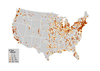
Data for << Shifting hotspots: Climate change projected to drive contractions and expansions of invasive plant abundance ranges>>
Annette Evans, Evelyn M. Beaury, Peder S. Engelstad, Nathan B. Teich, and Bethany A. Bradley
Invasive plant abundance data. Abundance data for 175 invasive plant species across the lower 48 United States. Each abundance record includes a UniqueID (numbers or characters that appeared to be a unique ID from the original dataset), the dataset from which the datapoint was derived from (see dataset_information.csv file for additional information on each dataset), decimal Longitude (Long), decimal Latitude (Lat), Species Code (SpCode, unique species identifier from USDA PLANTS database), cover (percentage cover), and CoverType (the type of abundance measurement in the cover column; either PercentCover, CoverClass, or AverageCoverClass).
