Effective April 1, 2024 the UMass Amherst Libraries will be pausing submissions to ScholarWorks as we transition to a new software platform. If you'd like to submit an item during this pause, please use this submission form to OneDrive.
ScholarWorks offers long-term storage and public access to the data and datasets produced by labs and researchers at UMass Amherst. You can submit your own data to ScholarWorks, or email the Data Working Group to schedule an appointment, ask questions, or learn more about how to deposit your data with us!-
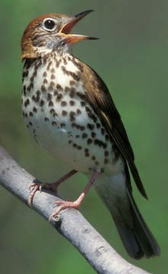
 by William V. DeLuca")
Designing Sustainable Landscapes: Representative Species Model: Brown-headed Nuthatch (Sitta pusilla)
William V. DeLuca
Brown-headed nuthatch was selected for the Designing Sustainable Landscapes project of the North Atlantic LCC (https://scholarworks.umass.edu/designing_sustainable_landscapes/) due to its associations with mature pine forests and pine plantations within the Coastal Plain and Piedmont in the Mid-Atlantic region of the NALCC. The Landscape Capability (LC) index integrates habitat capability, prevalence and climate suitability into a single index that reflects the relative capacity of a site to support the species.
-
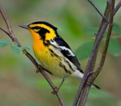
 by William V. DeLuca")
Designing Sustainable Landscapes: Representative Species Model: Blackpoll Warbler (Setophaga striata)
William V. DeLuca
Blackpoll Warbler was selected as a representative species for the Designing Sustainable Landscapes project of the North Atlantic LCC (https://scholarworks.umass.edu/designing_sustainable_landscapes/). The habitat clusters (ecological systems) and associated wildlife species that it represents generally comprise boreal coniferous forests and montane boreal forests in particular. The Landscape Capability (LC) index integrates habitat capability, climate suitability and prevalence into a single index that reflects the relative capacity of a site to support the species.
-
 by William V. DeLuca")
Designing Sustainable Landscapes: Representative Species Model: Black Bear (Ursus americanus)
William V. DeLuca
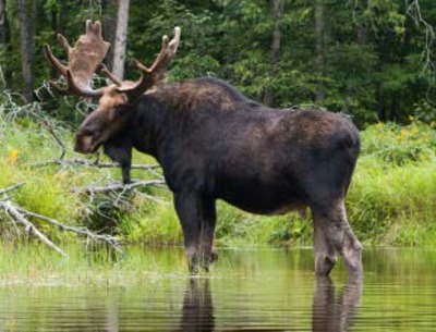
Black bear was selected as a representative species for the Designing Sustainable Landscapes project of the North Atlantic LCC (https://scholarworks.umass.edu/designing_sustainable_landscapes/). The habitat clusters (ecological systems) and associated wildlife species that it represents generally comprise of wetlands, early successional forests and mature hard mast-producing forests. The Landscape Capability (LC) index only includes Habitat Capability for this species. Climate niche (CN) is not estimated for black bear because its suitable climate conditions encompass the majority of North America. Therefore, it is unlikely that the northeast will experience climate conditions outside of this range by 2080. Prevalence is also not used for black bear LC due its extensive range in North America and the lack of broad scale occupancy data.
-
 databases and code by Bethany Bradley")
Abundance vs. Impact (AvI) databases and code
Bethany Bradley
These data represent 1258 empirical studies presented in 201 scientific publications used to meta-analyze the relationship between invasive species abundance and ecological impact.
-
 by William V. DeLuca")
Designing Sustainable Landscapes: Representative Species Model: Bicknell's Thrush (Catharus bicknelli)
William V. DeLuca
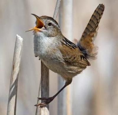
Bicknell’s Thrush was selected as a representative species for the Designing Sustainable Landscapes project of the North Atlantic LCC (https://scholarworks.umass.edu/designing_sustainable_landscapes/). The habitat clusters (ecological systems) and associated wildlife species that it represents comprise montane boreal forests. The Landscape Capability (LC) index integrates habitat capability and climate suitability into a single index that reflects the relative capacity of a site to support the species.
-
 by William V DeLuca")
Designing Sustainable Landscapes: Representative Species Model: American woodcock (Scolopax minor)
William V DeLuca
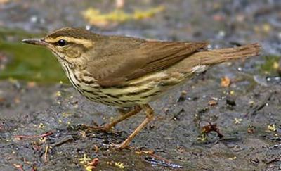
American woodcock was selected as a representative species for the Designing Sustainable Landscapes project of the North Atlantic LCC (https://scholarworks.umass.edu/designing_sustainable_landscapes/). The habitat clusters (ecological systems) and associated wildlife species that it represents generally comprise of northern fens, bogs, peatlands, and floodplain forests. The Landscape Capability (LC) index integrates breeding habitat capability and climate suitability into a single index that reflects the relative capacity of a site to support the species during the breeding season.
-
 by William V. DeLuca")
Designing Sustainable Landscapes: Representative Species Model: American Oystercatcher (Haematopus palliatus)
William V. DeLuca
American Oystercatcher was selected as a representative species for the Designing Sustainable Landscapes project of the North Atlantic LCC (https://scholarworks.umass.edu/designing_sustainable_landscapes/). The habitat clusters (ecological systems) and associated wildlife species that it represents are marine intertidal rocky coasts, mudflats and sand throughout the NA LCC. The Landscape Capability (LC) index integrates habitat capability and climate suitability into a single index that reflects the relative capacity of a site to support the species.
-
 by William V. DeLuca")
Designing Sustainable Landscapes: Representative Species Model: American Black Duck, Breeding (Anas rubripes)
William V. DeLuca
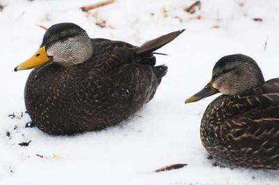
American Black Duck (breeding) was selected as a representative species for the Designing Sustainable Landscapes project of the North Atlantic LCC (https://scholarworks.umass.edu/designing_sustainable_landscapes/). The habitat clusters (ecological systems) and associated wildlife species that it represents generally consist of marshes, ponds and bogs. The Landscape Capability (LC) index integrates habitat capability, prevalence and climate suitability into a single index that reflects the relative capacity of a site to support the species.
-
\" by Darrel Ramsey-Musolf")
Data for "Evaluating California's Housing Element Law, Housing Equity, and Housing Production (1990-2007)"
Darrel Ramsey-Musolf
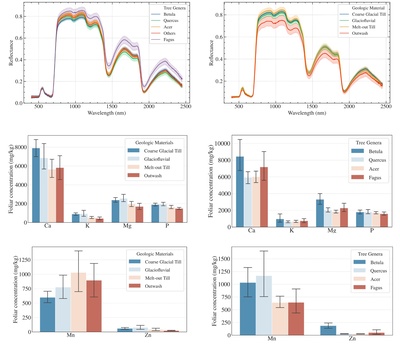
Since 1969, California’s Housing Element Law has required that municipalities address housing equity and housing production. In California, housing equity means that a municipality has planned for the future production of low-income housing that is priced from 0 to 120% of the U.S. Department of Housing and Urban Development’s median family income, and market-rate housing that is priced higher than 121%. For a purposive sample of municipalities (Sacramento and Los Angeles regions, 1990 to 2007, n = 53), this research found that as compliance with the law increased, the sample experienced deficient low-income housing production but surplus market-rate housing production. Mixed-effects models indicated that compliant municipalities were associated not only with increased low-income housing production but also with decreased annual housing production in comparison to noncompliant municipalities. While these associations contrast with Lewis, they suggest that municipal compliance may support California’s goal of providing housing equity but may also constrain California’s overall housing production.
-

Designing Sustainable Landscapes: Geophysical settings associated with the LANDSCAPE DESIGN paper
Kevin McGarigal, Brad Compton, Ethan B. Plunkett, Bill DeLuca, and Joanna Grand
Geophysical settings created by The Nature Conservancy used for our geophysical cores. See Anderson MG, Barnett A, Clark M, Ferree C, Sheldon AO, Prince J (2016) Resilient sites for terrestrial conservation in eastern North America 2016 edition. The Nature Conservancy, Eastern Conservation Science. https://easterndivision.s3.amazonaws.com/Resilient_Sites_for_Terrestrial_Conservation.pdf for details. [updated 9/10/18]
-

Designing Sustainable Landscapes: Alternative landscape designs associated with the LANDSCAPE DESIGN paper
Kevin McGarigal, Brad Compton, Ethan B. Plunkett, Bill DeLuca, and Joanna Grand
In this study, we developed 9 alternative sets of terrestrial cores based on various combinations of different biodiversity surrogates (species, ecosystems, and geophysical settings). We evaluated the compositional and spatial overlap among cores, and modeled the impact of 70 years of urban growth and climate change on future landscapes assuming each set of cores was protected. Each of the sets of cores (including the HUC6 Nature’s Network cores) are included in the data. [updated 9/10/18]
-

Data sheets for assessment of invasive species impacts
Bethany A. Bradley
These data sheets are an adaptation of the IUCN supported Environmental Impacts Classification of Alien Taxa (EICAT) protocol for assessment of impacts of invasive species. A text version of the protocol is available in Hawkins et al. 2015 (see readme file). The data sheets provide a standard format for reporting and summarizing invasive species impacts.
-

Designing Sustainable Landscapes: Total annual precipitation and growing season precipitation settings variables
Kevin McGarigal, Brad Compton, Ethan Plunkett, Bill DeLuca, and Joanna Grand
These two precipitation variables are among several ecological settings variables that collectively characterize the biophysical setting of each 30 m cell at a given point in time (McGarigal et al 2017). The amount of rainfall and depth of snowpack affects species composition, as well as ecological processes such as nutrient cycling. We’ve chosen two variables to represent precipitation. Both variables have future versions that incorporate climate change via General Circulation Models (GCMs) (as described in the technical document on climate, McGarigal et al 2017).
-

UNDP and World Bank development phrases
M.J. Peterson
Coding of the policy-related words or phrases used in the general policy section of each year's Annual Report of the Administrator for the United Nations Development Programme (UNDP) and the World Bank.
-

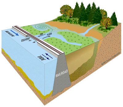
Designing Sustainable Landscapes: Critical Local Linkages
Kevin McGarigal, Brad Compton, Ethan Plunkett, Bill DeLuca, and Joanna Grand
Critical local linkages includes two Designing Sustainable Landscapes (DSL) products that measure the relative potential to improve local aquatic connectivity through restoration, including dam removals and culvert upgrades. A complete description of the critical local linkage assessment is provided in the technical document on connectivity (McGarigal et al 2017. Here, we briefly describe the dam removal and culvert upgrade layers. These particular products were initially developed for the Connecticut River watershed as part of the Connect the Connecticut project (www.connecttheconnecticut.org) — a collaborative partnership under the auspices of the North Atlantic Landscape Conservation Cooperative (NALCC), and subsequently developed for the entire Northeast region as part of the Nature's Network project (www.naturesnetwork.org). Briefly, each dam or road-stream crossing is scored based on its potential to improve local connectivity through the corresponding restoration action, but only where it matters — in places where the current ecological integrity is not already seriously degraded too much.
-

Designing Sustainable Landscapes: Northeast Aquatic Core Areas
Kevin McGarigal, Brad Compton, Ethan Plunkett, Bill DeLuca, and Joanna Grand
Northeast aquatic cores is one of the principal Designing Sustainable Landscapes (DSL) landscape conservation design (LCD) products for aquatic ecosystems and species, and it is best understood in the context of the full LCD process described in detail in the technical document on landscape design (McGarigal et al 2017). This particular set of products was developed for the entire Northeast region as part of the Nature's Network project (www.naturesnetwork.org) — a collaborative partnership under the auspices of the North Atlantic Landscape Conservation Cooperative (NALCC). Northeast aquatic cores represent a combination of lotic core areas (rivers and streams) and lentic core areas (lakes and ponds) selected at the Northeast regional scale to complement the lotic and lentic cores selected at the HUC6 scale (see aquatic cores document, McGarigal et al 2017) (Fig. 1).The HUC6 aquatic cores represent the primary LCD product for aquatic ecosystems; they were built to capture the best of each aquatic ecosystem in each HUC6 watershed in order to ensure a well-distributed network of aquatic cores across the region. However, the HUC6 scaling of the ecological integrity index (see IEI document, McGarigal et al 2017) from which the HUC6 cores were derived (see below) trades off some of the best areas of each aquatic ecosystem in the region for lower-valued areas in each HUC6 to achieve a more even distribution across the region for same total conserved area. The Northeast scaling of IEI forces the best areas of each ecosystem in the region to be included in the cores regardless of the final distribution.
-

Designing Sustainable Landscapes: HUC6 Aquatic Cores and Buffers
Kevin McGarigal, Brad Compton, Ethan Plunkett, Bill DeLuca, and Joanna Grand
The HUC6 aquatic cores and associated buffers represent some of the principal Designing Sustainable Landscapes (DSL) landscape conservation design (LCD) products for aquatic ecosystems and species, and they are best understood in the context of the full LCD process described in detail in the technical document on landscape design (McGarigal et al 2017). These products were initially developed for the Connecticut River watershed as part of the Connect the Connecticut project (www.connecttheconnecticut.org) — a collaborative partnership under the auspices of the North Atlantic Landscape Conservation Cooperative (NALCC), and subsequently developed for the entire Northeast region as part of the Nature's Network project (www.naturesnetwork.org). HUC6 aquatic cores represent a combination of lotic core areas (river and stream) and lentic core areas (lake and pond) selected at the HUC6 scale (Fig. 1). In combination with the terrestrial cores, they spatially represent the ecological network designed to provide strategic guidance for conserving natural areas, and the fish, wildlife, and other components of biodiversity that they support within the Northeast.
-

Designing Sustainable Landscapes: Local and Regional Vulnerability
Kevin McGarigal, Brad Compton, Ethan Plunkett, Bill DeLuca, and Joanna Grand
Local and HUC6 regional vulnerability are two of the principal Designing Sustainable Landscapes (DSL) landscape conservation design (LCD) products, which are best understood in the context of the full LCD process described in detail in the technical document on landscape design (McGarigal et al 2017). T These products were initially developed for the Connecticut River watershed as part of the Connect the Connecticut project (www.connecttheconnecticut.org) — a collaborative partnership under the auspices of the North Atlantic Landscape Conservation Cooperative (NALCC), and subsequently developed for the entire Northeast region as part of the Nature's Network project (www.naturesnetwork.org).
These two vulnerability products represent the vulnerability of high-valued places to future development, but differ in whether they reflect potential impacts of development on connectivity independent of any designated terrestrial cores (local vulnerability) or dependent on the designated cores (HUC6 regional vulnerability).
-

Designing Sustainable Landscapes: Probability of Development
Kevin McGarigal, Ethan Plunkett, Brad Compton, Bill DeLuca, and Joanna Grand
The integrated probability of development (probDevelop) is derived from an extraordinarily complex urban growth model described in detail in the technical document on urban growth (McGarigal et al 2017). The urban growth model is one of the major landscape change drivers in our Landscape Change, Assessment and Design (LCAD) model, in which it functions to simulate the stochastic growth of low-, moderate- and highintensity development during each 10-year timestep of a 70-year simulation between 2010- 2080. Because the urban growth model simulates the spatial footprint of development as a stochastic process, the development that occurs in any one simulation is merely a single stochastic realization of what could happen. Thus, any single urban growth realization is not particularly useful in landscape design. Instead, we developed this product to represent the integrated probability of development occurring between 2010-2080, which accounts for the type (low-, medium-, and high-intensity), amount and spatial pattern of development. This index represents the probability of development integrated across all of the possible development transitions occurring sometime between 2010 and 2080 at the 30 m cell level.
-

Designing Sustainable Landscapes: Northeast terrestrial ecosystem cores
Kevin McGarigal, Brad Compton, Ethan Plunkett, Bill DeLuca, and Joanna Grand
Northeast terrestrial ecosystem cores is one of the principal Designing Sustainable Landscapes (DSL) landscape conservation design (LCD) products, and it is best understood in the context of the full LCD process described in detail in the technical document on landscape design (McGarigal et al 2017). This particular product was developed for the Nature's Network project (www.naturesnetwork.org) — a collaborative partnership under the auspices of the North Atlantic Landscape Conservation Cooperative (NALCC). Northeast terrestrial ecosystem cores represents a set of terrestrial core areas derived using only ecosystem-based criteria (i.e., no species-specific criteria) and scaled to identify the highest valued places by ecosystem and geophysical setting within the Northeast region (Fig. 1). These core areas are intended to complement the HUC6-scaled terrestrial core areas and connectors (see terrestrial core area network document, McGarigal et al 2017) that were derived as the primary ecological network. These regional ecosystem-based cores help identify the best places for each unique ecosystem and geophysical setting within the entire Northeast region, whereas the HUC6-based cores help identify the best places within each HUC6 to ensure a well-distributed core area network across the region. Both of these products are designed to provide strategic guidance for conserving natural areas, and the fish, wildlife, and other components of biodiversity that they support within the Northeast.
-

Designing Sustainable Landscapes: HUC6 Core Tiers
Kevin McGarigal, Brad Compton, Ethan Plunkett, Bill DeLuca, and Joanna Grand
HUC6 terrestrial core tiers is one of the principal landscape conservation design (LCD) products, and it is best understood in the context of the full LCD process described in detail in the technical document on landscape design (McGarigal et al 2017). This particular product was initially developed for the Connecticut River watershed as part of the Connect the Connecticut project (www.connecttheconnecticut.org) — a collaborative partnership under the auspices of the North Atlantic Landscape Conservation Cooperative (NALCC), and subsequently developed for the entire Northeast region as part of the Nature's Network project (www.naturesnetwork.org). HUC6 terrestrial core tiers represents a two-tiered, spatially-nested hierarchy of terrestrial core areas and supporting landscapes. These tiers in combination with the HUC6 terrestrial core-connector network (see terrestrial core area network document, McGarigal et al 2017) and the aquatic core areas (see aquatic core areas document, McGarigal et al 2017) spatially represent a tiered ecological network for the Northeast region. This ecological network is designed to provide strategic guidance for conserving natural areas, and the fish, wildlife, and other components of biodiversity that they support within the Northeast.
-

Designing Sustainable Landscapes: HUC6 Terrestrial Core-Connector Network
Kevin McGarigal, Brad Compton, Ethan Plunkett, Bill DeLuca, and Joanna Grand
The HUC6 terrestrial core-connector network is one of the principal Designing Sustainable Landscapes (DSL) landscape conservation design (LCD) products, and it is best understood in the context of the full LCD process described in detail in the technical document on landscape design (McGarigal et al 2017). This particular product was initially developed for the Connecticut River watershed as part of the Connect the Connecticut project (www.connecttheconnecticut.org) — a collaborative partnership under the auspices of the North Atlantic Landscape Conservation Cooperative (NALCC), and subsequently developed for the entire Northeast region as part of the Nature's Network project (www.naturesnetwork.org). The HUC6 terrestrial coreconnector network represents a set of terrestrial core areas and the connectors between them. In combination with the aquatic core areas, they spatially represent the ecological network designed to provide strategic guidance for conserving natural areas, and the fish, wildlife, and other components of biodiversity that they support within the Northeast
-

Designing Sustainable Landscapes: Local and Regional Conductance
Kevin McGarigal, Brad Compton, Ethan Plunkett, Bill DeLuca, and Joanna Grand
Local and HUC6 regional conductance are two of the principal Designing Sustainable Landscapes (DSL) landscape conservation design (LCD) products, which are best understood in the context of the full LCD process described in detail in the technical document on landscape design (McGarigal et al 2017). These particular products were initially developed for the Connecticut River watershed as part of the Connect the Connecticut project (www.connecttheconnecticut.org) — a collaborative partnership under the auspices of the North Atlantic Landscape Conservation Cooperative (NALCC), and subsequently developed for the entire Northeast region as part of the Nature's Network project (www.naturesnetwork.org).
-

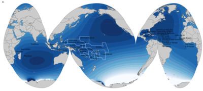
Designing Sustainable Landscapes: Subregions and urban growth associated with the SPRAWL paper
Kevin McGarigal, Ethan Plunkett, Lisabeth L. Willey, Brad Compton, Bill DeLuca, and Joanna Grand
